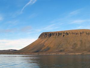
 The mountain Steinbeisfjellet in the inner part of the peninsula Frankenhalvøya. Dolerite pillars reminiscent of a set of teeth can be seen on the edge of the mountain plateau. (Image: Kit Kovacs & Christian Lydersen / The Norwegian Polar Institute)
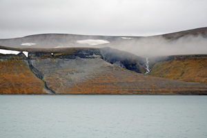
 Landscape in the west of Edgeøya. Vegetation, frost and erosion have created a square pattern in the mountainside, which is partially covered by vegetation. (Image: Marie Lier)
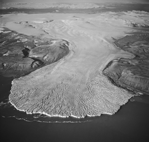
 The glacier Freemanbreen after its surge in 1956. At the back of the picture are the sound Heleysundet and Olav V Land. (Image: The Norwegian Polar Institute Photo Library)
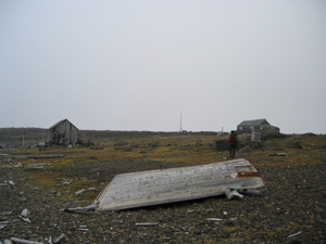
 Bjørneborg on the island Halvmåneøya. The bedrock consists of dolerite, a volcanic rock which yields an unproductive soil and hence scarce vegetation. (Image: Kit Kovacs & Christian Lydersen / The Norwegian Polar Institute)
The geology in the area mainly consists of sedimentary rocks from the Triassic, when Svalbard was completely covered by sea. The most common ones are sandstone, siltstone and shale that have derived from deposits in river outlets and in shallow shelf areas in the sea. The oldest rocks are from the Permian, and appear in small areas at the top of the north-eastern part of the island of Barentsøya as well as in the middle of southern Edgeøya. These old rocks consist of sandstone and limestone, often with fossils such as brachiopods (a mussel-like animal). Dolerite is a volcanic rock that hardened in the upper layer of the crust in the Cretaceous. It can be seen on the peninsula Frankenhalvøya in the north of Barentsøya, by the bay Russebukta and on the islands of Zieglerøya and Delitschøya in the south of Edgeøya. The islands of Tusenøyane, Halvmåneøya and Ryke Yseøyane consist entirely of dolerite that has been partially shaped like hexagonal pillars.
Most of Barentsøya and Edgeøya are covered in block fields and mineral soil formed through erosion and weathering. In the north-west of Edgeøya, large areas comprise raised shore deposits including old, easily visible shorelines. There are also large expanses of patterned ground on the islands. This phenomenon occurs when the action of the permafrost arranges small rocks in strips, circles or hexagons.
The landscape in the Søraust-Svalbard Nature Reserve is completely different from that of western Spitsbergen. The coastline is full of wide bays and there are no narrow, deep fjords and pointy mountains. The low, flat-topped mountains only reach 400-500 m in height. On the eastern side of the islands, large glaciers calve in the sea. The vegetation surprisingly lush in the western part of the islands.
Barentsøya covers an area of 1288km². At the top of the island is Barentsjøkulen, a glacier with several names inspired by Henrik Ibsen’s play, Peer Gynt: Solveigdomen (Solveig Dome) and Peer Gyntslottet (Peer Gynt Castle) stretch as tall as 650 m.a.s.l. The glacier covers much of the eastern part of the island with its area of 558 km². It has four branches that reach into the sea – Besselbreen in the north-east, Willybreen in the east, Freemanbreen and Duckwitzbreen in the west of the island. Freemanbreen had a marked surge in 1956, and the glacier front moved far into the sound Freemansundet. In the west of the island the landscape is dominated by mountain plateaus and moors.
Heleysundet is a narrow sound north of Barentsøya. It has violent tidal currents, although not as violent as those that occur in the narrow sound of Ormholet between the islands Kükenthaløya and Barentsøya. They both give a mighty impression. Many ships choose to go down the east coast of Barentsøya and enter Freemansundet between Barentsøya and Edgeøya to avoid the strong tidal currents in Heleysundet.
Edgeøya is quite similar to Barentsøya, however it has larger areas without ice, and the vegetation is quite rich in many places. Edgeøya is also much bigger – 5074km². Plateau mountains are also dominant here. The largest glaciers can be found in the south of the island, and especially in the south-east, where the glacier Edgeøyjøkulen covers an area of 1365 km². The glacier Stonebreen, a branch of Edgeøyjøkulen, forms a long, steep glacier front towards the Barents Sea in the east. Eastwards into the sea from here lie the three small islands Ryke Yseøyane. The landscape differs from the east to the west of Edgeøya. The most distinctive features of the west are the fjord Tjuvfjorden with the large lagoon Tjuvfjordlaguna, and the valley of Dyrdalen. Further north the landscape changes again. In some places it rises straight from the sea up to 350-500 m.a.s.l. In other places the gentler landscape features strandflats and plateaus athat resemble waves washing towards mountains and valleys in the background.
South-east of Edgeøya is the island Halvmåneøya, with a long history of whaling, hunting and trapping. South of Edgeøya lie the islands of Tusenøyane, which are surrounded by shallow waters that have been poorly mapped, making sailing here very risky. Tusenøyane consist of a large number of small islands scattered over an area of about 2500 km².