Nordvesthjørnet's geology and landscape
By Øystein Overrein (ed.), Jørn Henriksen, Bjørn Fossli Johansen, Kristin Prestvold
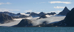
 From Smeerenburgfjorden towards Kvasspiggen (670 m.a.s.l.), Kvasspiggbreen and Scheibreen. (Image: Bjørn Fossli Johansen / The Norwegian Polar Institute) From Smeerenburgfjorden towards Kvasspiggen (670 m.a.s.l.), Kvasspiggbreen and Scheibreen. (Image: Bjørn Fossli Johansen / The Norwegian Polar Institute)
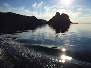
 Klovningen, seen from Cooksundet. This landmark was first described by Willem Barentsz in 1596. (Image: Bjørn Fossli Johansen / The Norwegian Polar Institute) Klovningen, seen from Cooksundet. This landmark was first described by Willem Barentsz in 1596. (Image: Bjørn Fossli Johansen / The Norwegian Polar Institute)
The north-western corner of Spitsbergen, from Magdalenefjorden in the south to Biscayarhuken in the north, consists of several large islands, sounds and fjords which cut in between alpine mountain formations. This area lies entirely within the borders of Nordvest-Spitsbergen National Park.
The bedrock belongs to the old basement and consists of crystalline rocks such as granite, gneiss and migmatite. Younger, reddish Devonian sandstones occur on the south and east side of Raudfjorden.
The landscape has been shaped by the glaciers, which erode the rock so that the mountains end up with sharp crests. There are many smaller glaciers in Nordvesthjørnet. Smeerenburgbreen, in Bjørnfjorden, is the largest one of these glaciers, the front measuring 7 km.
|