Did you know that radars are used to find hidden lakes and safe paths?Doctors use x-rays to peer inside the human body. Glaciologists use radars to peer into and under the deep blue ice – and to ensure safe travel in Antarctica.

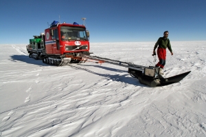
Within glaciological research, radar data are incredibly important. Using radars, scientists can clearly see structures in the snow and ice, even those a couple hundred metres deep in the ice. Radars also provide information about the terrain and conditions under the ice. There are many types of radars. Some can be transported manually on sleds or towed behind snowmobiles or tracked vehicles. Others can be mounted on planes or helicopters, and even satellites can be fitted with radars. From 2007 to 2009, scientists from the Norwegian research station Troll in Dronning Maud Land travelled to the South Pole and back in tracked vehicles and sleds. Along the entire route, radars that were towed behind the vehicles measured ice thickness, layers within the ice, and bedrock topography. To ensure that the expedition followed a safe path over the glaciers – avoiding all crevasses – the vehicle at the head of the column was outfitted with a radar. It was attached to the vehicle’s front and was directed so that it would “see” cracks and caverns in the top 15-20 metres of the underlying snow and ice, thus allowing the expedition to pass safely through dangerous areas by steering away from deep crevasses. Read more about the Norwegian-U.S. scientific traverse from Troll to the South Pole and back at the project's web site. |
South Pole 1911–2011 is an informational outreach project run by the Norwegian Polar Institute
Contact person:


