Did you know that Africa and Antarctica were once neighbours?
About 500-600 million years ago, the supercontinent Gondwana was formed. This ancient continent consisted of Antarctica, Africa, India, Australia and South America.
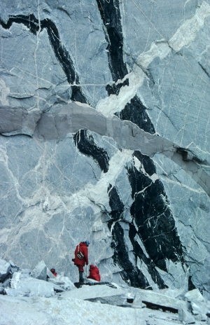
 A cliff face in Jutulhogget not far from the research station Troll. Criss-crossing magmatic dikes reveal the sequence of events that have occurred deep inside the earth through the eons. Photo: Synnøve Elvevold / Norwegian Polar Institute
At that time, Dronning Maud Land shared borders with Africa, Madagascar, Sri Lanka and India. About 200 million years ago, Gondwana started to break apart and some pieces (e.g. Africa and India) began to drift northward towards their current positions.
Fossilised remains of ferns, freshwater fishes, amphibians and reptiles prove that Antarctica has not always been covered in ice. It is likely that the continent has been glaciated repeatedly during the past 40 million years, and it is the eroding power of ice that has sculpted the mountains and landscapes we see today. The shapes of the mountains depend on the composition and structure of the bedrock. Different types of rock weather differently: hard rocks will give rise to nunataks and mountains with sheer cliffs like Stabben in Antarctica. Stabben consists of coarse-grained syenite, a rock that is much more resistant to erosion than the gabbro that makes up most of the other mountains in the area.
Geologists study Antarctic mountain formations to learn something about geological processes, both to figure out what became of the ancient continent Gondwana, and to understand processes hidden far below the earth’s surface.