Hinlopenstretet's geology and landscape
By Øystein Overrein (ed.), Winfried Dallmann
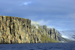
 Alkefjellet in Hinlopenstretet. The cliffs consist of dolerite. (Image: Jørn Henriksen) Alkefjellet in Hinlopenstretet. The cliffs consist of dolerite. (Image: Jørn Henriksen)
 Verlegenhuken’s flat neck of land is the northernmost point of Spitsbergen and stretches as far north as 80 degrees and 4 minutes. (Image: Bjørn Fossli Johansen / The Norwegian Polar Institute) Verlegenhuken’s flat neck of land is the northernmost point of Spitsbergen and stretches as far north as 80 degrees and 4 minutes. (Image: Bjørn Fossli Johansen / The Norwegian Polar Institute)
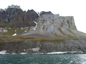
 Kapp Fanshawe, where Lomfjorden flows into Hinlopenstretet. The dark mountain comprises a dolerite from the Mesozoic (65-245 million years ago). The dolerite, which has intruded a limestone from the Carboniferous (290-360 million years ago) was formed when basaltic magma crystallized within fractures in the crust. Dolerite is found in many places around Hinlopenstretet. (Image: Winfried Dallmann / The Norwegian Polar Institute) Kapp Fanshawe, where Lomfjorden flows into Hinlopenstretet. The dark mountain comprises a dolerite from the Mesozoic (65-245 million years ago). The dolerite, which has intruded a limestone from the Carboniferous (290-360 million years ago) was formed when basaltic magma crystallized within fractures in the crust. Dolerite is found in many places around Hinlopenstretet. (Image: Winfried Dallmann / The Norwegian Polar Institute)
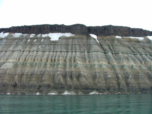
 Limestone and sandstone strata from the Permian period in Selanderneset on Nordaustlandet. (Image: Winfrid Dallmann / Norwegian Polar Institute) Limestone and sandstone strata from the Permian period in Selanderneset on Nordaustlandet. (Image: Winfrid Dallmann / Norwegian Polar Institute)
The area described here is the strait of Hinlopenstretet itself, as well as the areas north and south of it. The north includes the northernmost point in Spitsbergen – Verlegenhuken – while the fjord Sorgfjorden enters Spitsbergen a little further south. Murchisonfjorden, with its many headlands and islands in a relatively flat landscape, is located north of Hinlopenstretet.
The bedrock north of the fjords Lomfjorden and Wahlenbergfjorden is quite old, and the landscape is characterized by several large strandflats. Lomfjorden extends southwards from Hinlopenstretet in between the steep mountains of the island of Spitsbergen, while Wahlenbergfjorden stretches eastward between Nordaustlandet’s small mountains and enormous glaciers. This is a transitional zone between the older basement and younger cover rocks. The cover rocks are mostly Carboniferous and Permian limestone and dolomite rocks, which are intruded by the resistant dark dolerite.
In the south, Hinlopenstretet opens up, with a large number of small and large islands. The scenery here is completely dominated by large glaciers.
|