
The headquartersNot surprisingly, the headquarters of Arctic Ltd are in the Arctic. Everyone knows that this lies far to the north, but how it is demarcated towards the south is perhaps not so well known. One possibility for drawing a southerly limit for the Arctic is to use a line of latitude, and the one that is most commonly used is the Arctic Circle. It marks the latitude where the sun does not rise above the horizon for at least one day at the winter solstice, about 21 December, and where there is at least one night of midnight sun at the summer solstice, about 20 June. However, as most organisms in the Arctic do not just depend upon light to exist, climate is a more relevant definition, and the distribution of permafrost or the area north of the 10 °C July isotherm are generally used. The isotherm is the boundary where the average temperature for July is no higher than 10 °C at sea level. It is also possible to use the vegetation and the northern treeline to demarcate the Arctic. A boundary for the Arctic is not only required on land. In the sea, it is drawn where cold, low-saline water from the north meets warmer, saline water from the Atlantic Ocean. Because the Gulf Stream along the Norwegian coast takes the Atlantic water much further north than it reaches around Canada and Greenland for example, the salinity boundary in the ocean is situated at about 80°N west of Svalbard, whereas it is around 65°N on the east coast of Greenland. In addition to these purely geographical and climatic delimitations, politics and culture also play a role, and one could just as well add several lines to illustrate political and cultural definitions of the Arctic. The Norwegian part of the Arctic is defined as Svalbard, Jan Mayen and the mainland north of the Arctic Circle. For practical reasons, a small area south of the Arctic Circle is also included to take in all the Saltfjellet-Svartisen National Park and the Borough of Rana. Even though the Norwegian Arctic also includes some of the mainland, our attention here is focused on Svalbard and the surrounding waters, including part of the Barents Sea. The Svalbard archipelago comprises eight large islands and all the small islands, islets and skerries between 74° and 81° North and 10° and 35° East. The largest island is Spitsbergen. 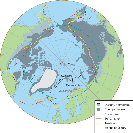 The Arctic can be defined in a variety of ways such as by the distribution of permafrost, the Arctic Circle, the 10 °C isotherm, the treeline and/or the salinity boundary in the sea. As the map shows, most boundaries of the Arctic are drawn further north in Norway and Scandinavia than in the rest of the world. This is because a branch of the warm Gulf Stream flows northwards along the coast of Norway and continues past Svalbard into the polar regions. The Arctic can be defined in a variety of ways such as by the distribution of permafrost, the Arctic Circle, the 10 °C isotherm, the treeline and/or the salinity boundary in the sea. As the map shows, most boundaries of the Arctic are drawn further north in Norway and Scandinavia than in the rest of the world. This is because a branch of the warm Gulf Stream flows northwards along the coast of Norway and continues past Svalbard into the polar regions.Illustration: Audun Igesund, NPI |
   |